Topograph Study Report
 A systematic and scientific slope and topography study was conducted by hiring technical consultants as per BMZ guidelines and the study gives a systematic treatment measures at the catchment, water spread and command areas. This is report also provide opportunity to reconfirm the logical sequence of the project activities as well mainstreaming the project components as well target group with government system aimed at sustainability. As a part of the topographical study Soil Samples was given to Tamilnadu Government Soil Research Station at Aruppukottai for analysis and their recommendations. The recommendation assists the project in crop selection and judicious use of project resources.
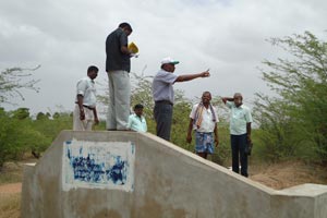
Based on the recommendations of the technical expert on Topography study, a detailed Participatory Rural Appraisal was deployed to conduct PRA exercises at individual lake and pond level. This is aimed at improving participation of the target groups and blending the local knowledge with technical data.
PRA tools employed included resource mapping, watershed mapping from local farmers perspective, comparative analysis of the technical study report and focus group discussion followed by transect walk. Participatory treatment plans were made with beneficiary farmers with special emphasis on identification of slope, vulnerable eroded patches and gully for treatment fixing checks and decide on the land see pattern for count our treatment and bundling options.